
|
|
I was honestly thinking we were not going to have a single storm during the entire 2020 warm season, with so much high pressure and the return of Nly air flows it seemed that the chance of a proper thunderstorm was nothing but fantasy, in truth, I was mentally preparing myself for the realization that I might have to wait until the Summer of 2021. Then a major pattern shift suddenly appeared on the models with an unsettled and very unstable theme which looked to produce several back to back days of thunderstorms across Ireland and N. Ireland, and just like that the tables had turned and with many lock down restrictions now lifted it looked like I would be storm chasing on June 14th and 15th. The synoptics looked very promising with high resolution models indicating 1000-1300 CAPE and a lifted index between -3 and -5, in addition to this the air aloft where storm tops would live would be colder than -30 degrees C with steep lapse rates and plenty of juice. The main source of lift was solar heating and a pronounced convergence zone, the flow would be from the E however a sea breeze from the N would converge with the surface flow, this meeting of air masses looked to take place across the W midlands of N. Ireland however it was more focused to the far W of the country.
Convergence acts an additional source of lift forcing air aloft and hence aiding with the formation of vertical updraughts, convergence also can be the focal point for funnel clouds and tornadoes. I really liked the deep instability, we had went from nothing to a day of convective showers with 50 CAPE to suddenly being assaulted by 1300 CAPE, these values are the real deal, the set-up promised deep convection, the surface flow was rather slack which meant storm motion would be slow which I like to see, slow storm motion would mean being able to chase cells more effectively and would help benefit my storm time lapse project. I assumed there would be no shear so I was fully expecting pulse storms, however when I looked at the charts I got a shock, across the midlands were 20-25 knots of DLS however on the west coast by evening time there would be 40 knots of DLS. This had me very interested indeed, this meant a risk of slow moving multicell thunderstorms however further W the shear was certainly strong enough for supercellular traits. After going through an extended storm drought nature had suddenly presented me with a golden storm chasing opportunity.
I have to admit I was very excited by the prospect of a proper storm chase and my emotions rather got the better of me, I felt like how I used to feel about storms back in 2009 when the prospect of a storm completely dominated my life. It seemed little has changed, I thought after all these years of chasing I would have adopted a more cool mental approach born from experience and age, but no, my passion burned as strong as ever and the adrenaline and excitement began to build in anticipation of the big day. I used the time to prep my gear, I hand washed the entire van, sterilized and cleaned the interior, checked my oil and fluids, I had just bought four brand new tires and had their pressure checked. After this I sorted out all my camera gear, I formatted memory cards, charged all batteries belong to the DSLRs and drone and Go Pro, cleaned lenses, cleaned sensors, tightened up any loose components within my tripods and packed spare batteries for my intervalometer and made sure they worked. All this preparation was important however it was much a form of mental preparation as it was a tech check.
The evening before chase day I went to the shops and purchased mineral bottles and snacks for the road, both healthy and not so healthy, filled up my canteens with fresh water, brought tops and coats incase the rain was bad and a spare set of boots then almost filled the tank with diesel. I felt I was as ready as I could have been, it was now up to nature and to me to make the correct decisions while on the road. Storm chasing is very exciting and fun however it can also be challenging mentally as the pressure is high to get a result, this strain is even more potent if you had no season at all up to this point in time so the few days you do get need to produce something photogenic. On the night of the 13th a convective outlook was issued for the following day, in fact, convective weather had placed us in a slight risk box and even mentioned that it could be upgraded to moderate risk when reviewed later. I stayed up late into the night studying models and forecasts and chatting with the guys.
Based on the models we all agreed that the best target would be the W within Tyrone, Fermanagh, Donegal and Sligo, in all likelihood we would be hitting the latter and could very well end up at our old favorite storm viewing location at Mullaghmore. A plan was formed and it soon became apparent that all of us would be chasing, five of us would be heading W together however due to Covid-19 restrictions we had to keep our distance so we couldn't share cars which meant we all had to drive. We all agreed to meet the following morning in Omagh as a base of operations and from there we would make a decision on our chase when new intelligence became available. That night at 01.00 BST I walked into the back yard, I was in a t-shirt and still felt warm on this lovely mild Summer's night, there were good clear sectors, I watched Deneb and Vega twinkle lazily and scanned the northern sky for Noctilucent Clouds, I didn't see any and this time I was glad for I needed my rest as tomorrow promised to be an action packed day, it was a long time before I finally drifted off to sleep.
I woke up sharp and early on the morning of the 14th, I had breakfast early then packed the van with supplies, opened the windows to air out the inside then placed my two camera bags on the passenger seat with zips open and camera settings already selected for daytime cloud exposures. I had two tripods in the foot well and my 100-400mm lens in its carry bag hanging over the seat. All this was further mental preparation, it meant all my gear was within arms reach so I could pull over quickly and get images with as much efficiency as possible. It was a glorious morning, even at 09.30 it was hot, the sky was blue and I could feel the humidity, this definitely felt like a storm day. I went back inside and checked the models, everything still looked great, in fact, this looked like one of those rare occasions when all the parameters looked prime for thunderstorms. The Met Office had issued a yellow warning for thunderstorms and models indicated storms could fire early. I love waking up on a storm day when the sun is already warm and baking the ground, with temps expected to reach 24-25 degrees C or more and with no cloud expected it looked like we were going to get tremendous solar heating. Our plans were finalized, I would meet John Fagan in Omagh, Nigel McFarland would meet me in Cookstown and later Paul Martin would join us in Omagh. We also had a new member to the team in the form of Colleen Webb from Portglenone who has a big interest in storms and was as passionate as us to chase this set-up so she joined us for the day and would meet us in Omagh also.
I was ready to go, I said goodbye to Roisin, she genuinely hoped we would all see something cool as she knows that more often than not these storm forecasts can often end in disappointment but I was confident this day would produce. I walked around the corner and there was Nigel, bang on time and keen to chase. He surprised me with a hand held walkie talkie, he gave me one of the hand sets, we now could chat to each other as we drove that way we could comment on the clouds and make decisions and navigate the roads with greater efficiency so Nigel and I headed out the road, the radio was up loud, the van was hot and the blazing sunshine cooked the lush countryside, the adventure had begun, I really live for moments like this.
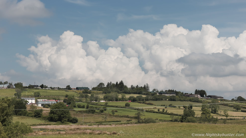 |
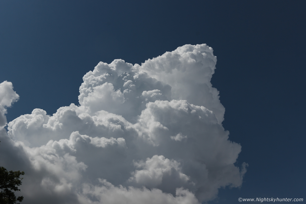
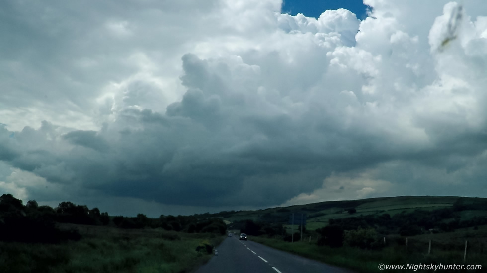
We drove along the Cookstown-Omagh road, one of my favorite chase locations, the road is mostly surrounded by countryside and offers wide open vistas suitable for watching the bases of storms. We observed convection building and with nothing else of note in the otherwise blue sky we decided to pull into a lay by and take a look. A line of capped but yet potent convection was in the process of building at a modest pace in the form of a train of towering cumulus, their heads seemed to stir in response to the heat and with time they could be seen visibly developing, getting taller and broader, still hitting that invisible cap but already at this hour the stage was set, we knew from watching these towers there were going to be storms today, it was only 11.40 and the sky was showing very promising visual cues. Moving R to L (E to W) in this image, these had formed over the Sperrins and along the sea breeze convergence zone, as the towers moved further west and once full afternoon heating and CAPE could be utilized we would be in action.
 |
We met Colleen Webb and John Fagan at a car park in Omagh, we had a quick chat about the set-up and our plans, strong towers bubbled up over the tree tops as if showing us the way, Colleen did a check online and noted that TORRO had issued a convective discussion for our target area for thunderstorms with frequent lightning, flooding risk and convergence derived tornadoes. We began chasing, this time four cars chasing in unison, we decided to target those same towers we had seen recently, we took the main road between Omagh and Strabane and headed N towards the convection which by now had morphed into huge updraughts which slowly drifted R to L over this wind turbine farm.
 |
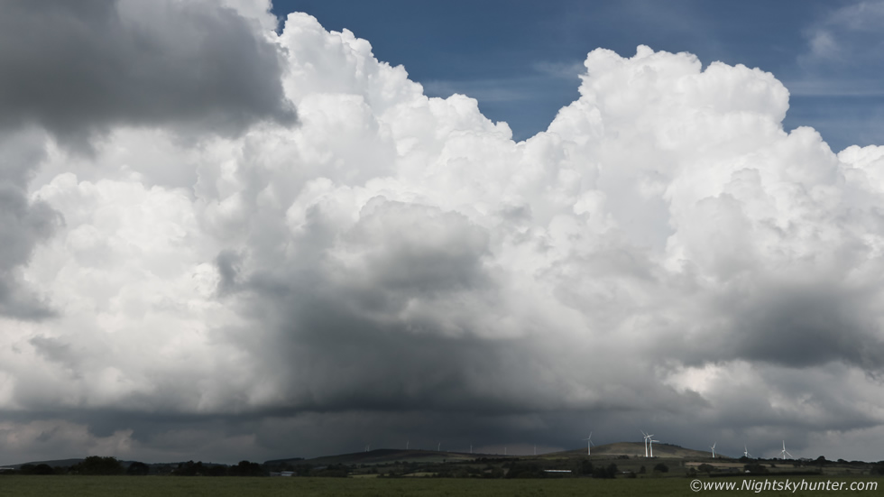
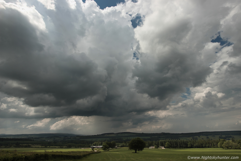
It was a small bending country road, I don't know how all of our cars got parked, we had pulled up beside a gate to a vast lush field with cars and vans half way on the grass verge, we just hoped a tractor didn't take this road. As we watched the convection turned explosive, the kind of powerful boiling updraughts one would see in the USA, the convergence line had an entire cycle of towers going up and down, crisp, brilliant white, like cauliflowers on steroids. Every base was solid and well defined and they had that 'warm' look to them, the look often associated with warm core set-ups, with an abundance of humidity, the LCL was low so bases were surface based, a funnel cloud was possible anytime. I climbed over the gate and set up my 600D and tripod in this field and began shooting my second time lapse of the day. Nigel and Colleen were shooting over the gate and we did a little vlog filming too, then the cap broke and we heard our first thunder of the day, actually or first thunder of 2020 and it was a sound which made us all smile. Red cores were forming in this line via radar, it was only noon and we had a storm, actually two, one to the right and the other further away, we heard five or six rumbles, this day meant business.
At this moment in time I was in absolute heaven, this is what I had been waiting for all year, this is what I yearn for and thought about and read about during lock down and now I was finely free and nature was set loose. One of my happiest moments in life is standing in a large open field, the scent of the grass or crop in the air, the sun cooking my skin, the humidity making me sweat, wearing my lucky baseball cap and looking up at explosive updraughts as thunder rumbles, there really is no better feeling in the world. Two walkers passed us then came over for a chat, they were curious to what we were doing so we explained about our interest in thunderstorms and photography and they were fascinated, we pointed out the updraughts and about the storm risk, they made a note of our web sites and facebook pages then headed home to enjoy the show from their gardens.
 |
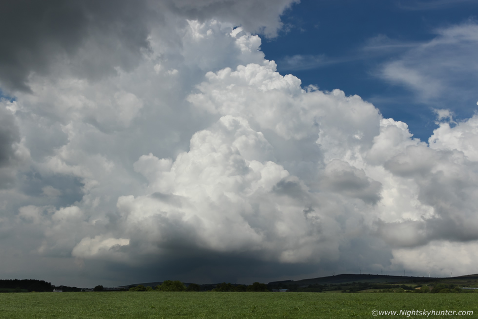
At this moment in time I witnessed the most explosive convective development I have ever seen in my life. I have observed impressive convection in 2009, 2014 and a hand full of other times however this was on another level entirely. We stood gob smacked by the caliber of the updraughts we were seeing, they seemed to grow so fast their real time movement was like watching a time lapse movie, we honestly couldn't believe it, there are no words to describe the sight. This was like watching an expanding mushroom cloud from an atmospheric eruption, the upward and sideward formation was jaw dropping, you could see the energy being unleashed as you watched, I will never forget this moment, this is looking up at that remarkable scene from Mother Nature. The atmosphere felt damp on our skin, the moisture/humidity was perfection, it felt like all the ingredients were in place for a great day ahead, I thought to myself if this was after noon what would 17.00 bring?
 |
We drove on up the mountain which brought us closer to several new developing towers then pulled over to watch, this was near the entrance to the turbines on Bessie Bell. The base began to get interesting with irregular features forming which began to rotate, right side moving R to L and left side moving L to R, we really thought we could get a funnel cloud here, we grabbed the cameras and made them ready. That nice tree got our attention, it would make for a cool foreground subject so we got it lined up ready for our funnel.
 |
55mm zoom into the base, that large grey form was turning, then vanished, no funnel but it was a scenic moment and the only 20 min's we got during the entire day to relax. Paul Martin met up with us, we needed a new game plan, radar showed that thunderstorms had erupted in a big way below the border with red and white cores, they were heading W, that was all the intell we needed, we hit the road once more.
 |
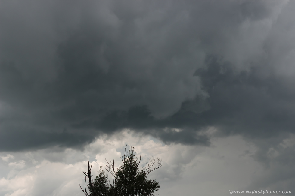
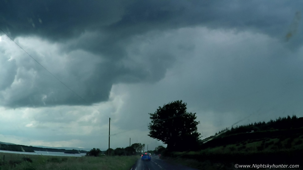
I don't mean to sound corny but this part of the chase actually felt like a chase scene from the movie twister. Five vehicles all from the north chasing west into Ireland, one behind the other, two vans and three cars, all storm chasers on a mission. It hit me when we were in pursuit that I was experiencing storm chasing history in N. Ireland, I've never been aware of five chase vehicles all together chasing the same target as a team, it was quite surreal and also humbling to be in the company with people of a similar mind set, we all had passion, tenacity and a desire to experience nature at her finest. Nigel and I chatted over the walkie talkies about the clouds, discussing towers and bases, this cool updraught base came into view outside Kesh with an interesting lowering, I took this 10mm snap shot out the window for the record. We pulled into the filling station at Kesh, a very quick pit stop, that updraught base was from a developing storm, it let out a rumble and the precip core was white the over Belleek area. We grabbed drinks and snacks from the shop, I had a quick chat with two bikers at the pumps who admitted to having an interest in storms, they had observed rotation within that updraught base.
 |
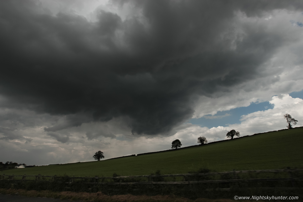
We continued SW into Co. Fermanagh, the clouds got meaner the further W we drove, this was a nice cell going up in front of us, solid towers, dark well defined base and updraughts leaning over to the right due to the strong speed shear aloft, this is a still taken from the window mounted Go Pro.
 |
Same base a little later, love the structure in this scene, the base was young and compact, well separated from the precip core to the R and even has a vault region, all characteristics of strongly sheared cells. That's John Fagan's car in front, he was pointing out the window at the sky, I knew he was thinking the same thing I was. As we continued driving my attention was drawn to an impressive storm scene to my 9 o'clock position, the sky was dominated by the solid tops of the anvils belonging to those storms below the border, they were still moving W and we should intercept them at our target area, then the base came into view, it was massive extending across a large area of sky, solid black with dark scud rising upward feeding into the base, there was also a bulge in the middle of the base which looked like a bell shape, it had all the hall marks of a storm with transient supercelluar structure, I could only get fleeting glimpses as we drove but given the 40 knots of deep layer shear affecting this area the structure wasn't a surprise. Imagine dead calm at the surface, or just a gentle breeze you would barely notice, however 30,000ft above you the wind is blowing at 40 knots, those huge updraughts would be encountering that wind aloft and tilting over aiding with their organization.
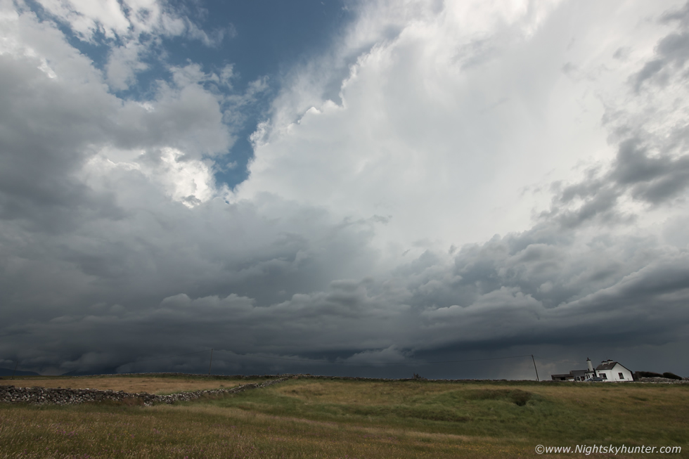 |
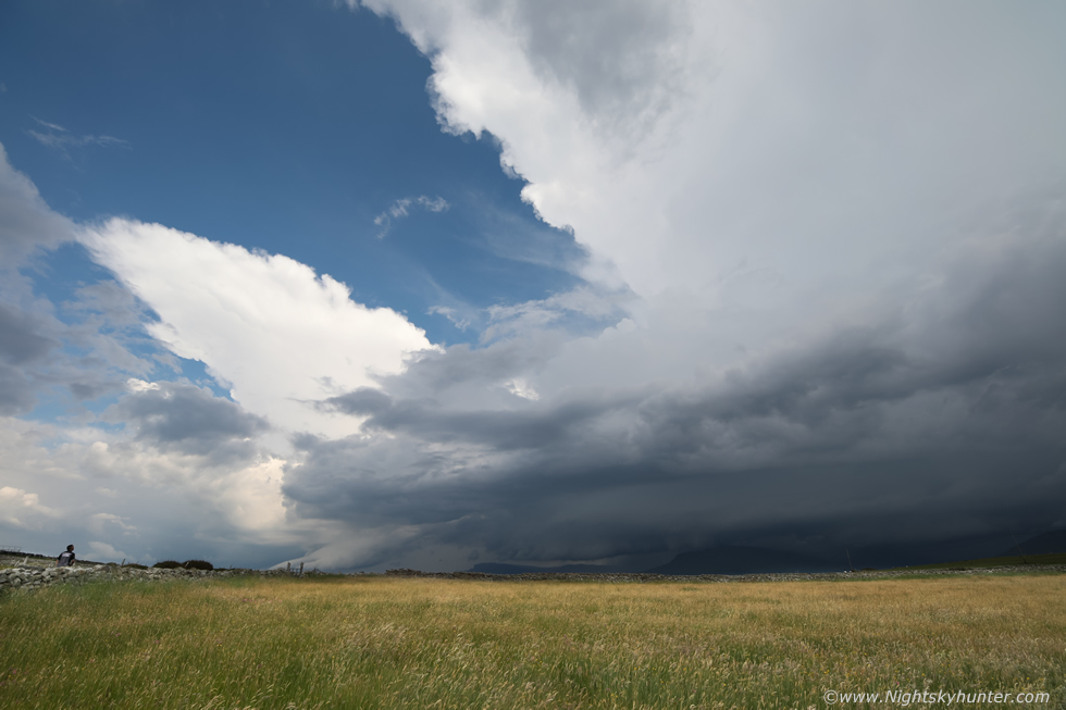
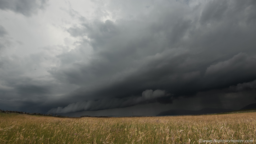
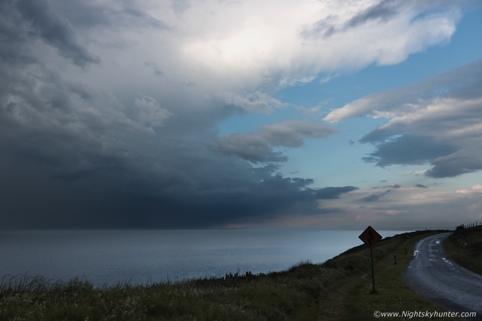
We arrived at our old storm spotting location at Mullaghmore in Co. Sligo on the west coast of Ireland, back at Kesh filling station I had mentioned to Colleen about how this location produced for us nine times out of ten including some of our finest storm memories ever experienced, we had just arrived and it was paying off already, our arrival coincided with arrival of that massive storm I had spotted back down the road. I got out to bask in the glory of this magnificent thunderstorm, I'm shooting with full wide angle lenses for these, the storm was so massive I couldn't get it all in the frame. The clouds were mean and dark, regular deep angry rumbles could be heard from deep within it's belly, the other side of this storm extended far out of frame to the left, you can see the anvil top building and sheared downrange to the R with precip falling over Benbulbin Mountain. Moving towards us and L to R at same time, we were all out and buzzing with excitement, we had come all this way for a storm and now we had it, we gave yells of delight, this chase was now a complete success, our target area was bang on, anything else would be icing on the cake.
 |
What a scene to be greeted by, monster multicell storm on a convergence line with base hugging the fields and vast anvil stretching beyond the frame. The light was fantastic with sunshine making the fields contrast vividly against the approaching dark storm. I love these Irish stone walls, they made for fantastic foreground interest. Paul and Colleen can be seen on the crest of the hill studying the storm, this was taken with the Canon 600D at 10mm wide angle, you can see another cell at the far end of the complex with anvil sheared to the W, that cell section was also coming our way.
 |
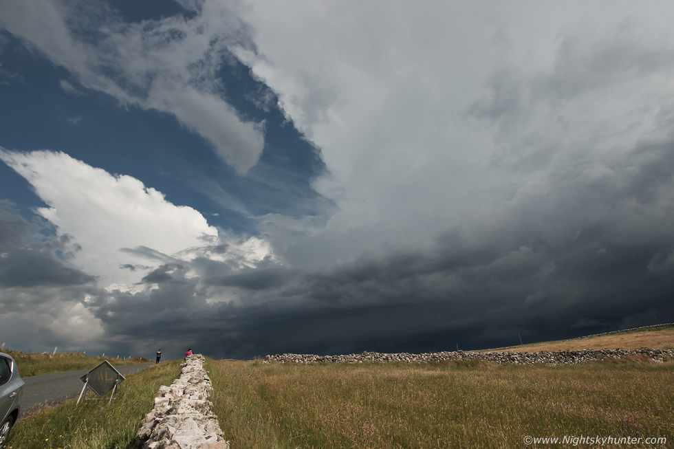
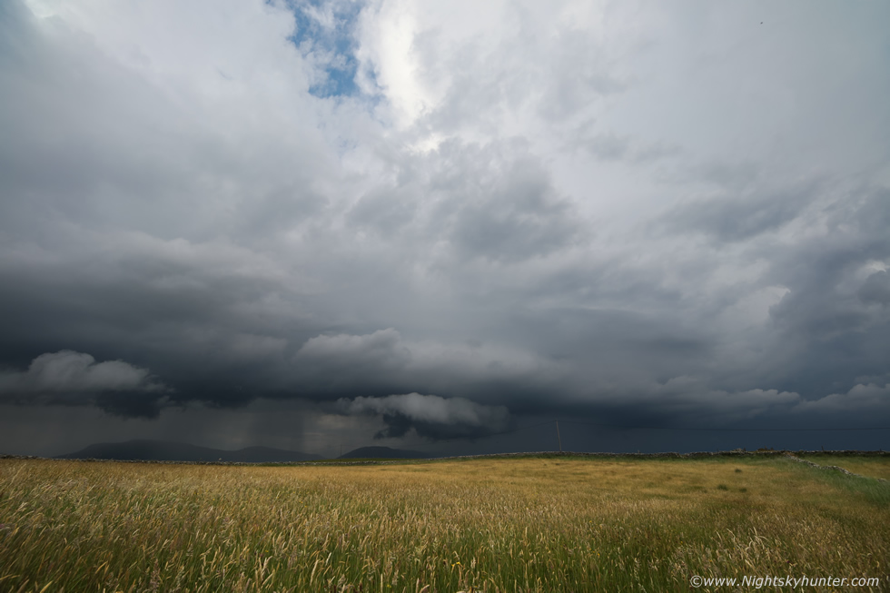
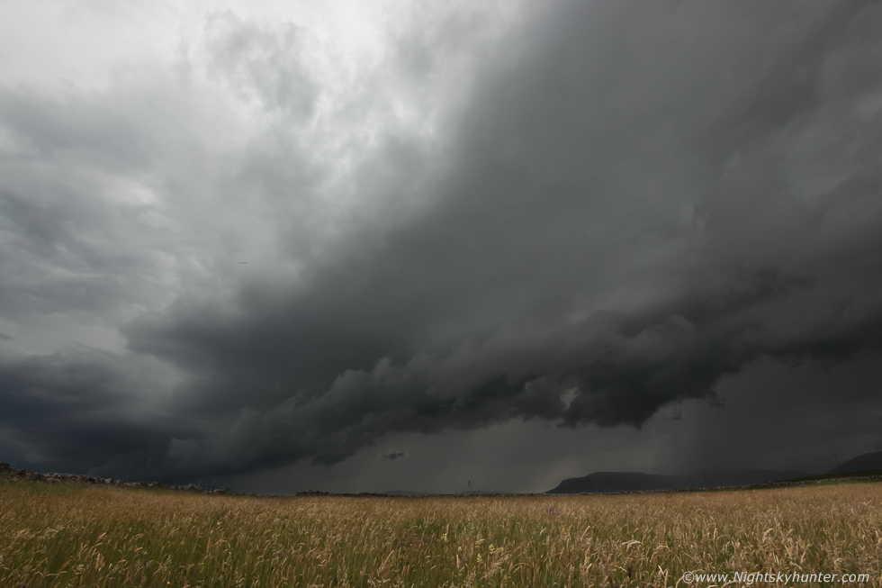
This was like a scene straight out of the great plains, large sheared thunderstorm over the peaks of Benbulbin contrasting against the sunlit Irish fields, an unforgettable moment. It's rare to get a major storm in such good light in this country and even more so to get clear blue skies around the anvil during warm sector storms in Ireland, however on this day we were getting the full show. The storm rumbled, thunder louder and more frequent, lightning could be seen within the precip to the right. The base was developing interesting structure, some portions looked to have inflow features while other areas were getting under cut by outflow, the middle and left sides were forming a shelf cloud.
 |
Paul to the L marveling at the storm, the above two images were taken with my new Canon 5D Mark IV with Irix 15mm F/2.4 lens, this was the camera's first proper storm chase and it was now earning its keep. I was impressed by the large full frame sensor's high dynamic range and how clean the images were, also the Irix 15mm lens was as sharp as a razor, the system done me proud. Yet again living my dream, standing in a field of tall grass at a famous tourist hot spot, kneeling in the grass under hot sunshine with the scent of the grass and the deep loud rumbles of thunder with a shelf cloud slowly approaching me, this is my happy place. I began shooting time lapse using the 600D and 5D Mark IV, both wide angle, taking one image every second, this was my third time lapse shoot of the day, I had a feeling this was going to turn out great. Both DSLRs clicked as the shutter worked continuously, I stood and listened and made sure the cameras were operating correctly then stood back and watched. I realized I might just have enough time to get the drone up so I ran back through the grass, over the stone wall and back to the van and let the cameras do their magic.
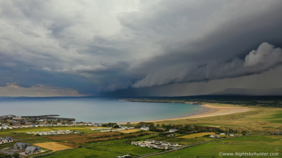 |
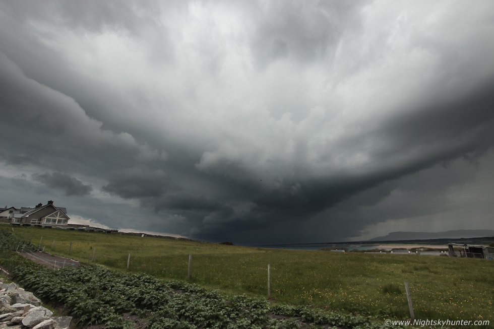
It was a race against time to get the aerial view before the precip hit, it seemed to be getting closer by the minute. I launched the Mavic 2 Pro from my hand and sent it 90m high above the field, the cameras were already shooting the R side of the storm so I panned the drone to the left side, which at the time I couldn't see from the ground due to a hill in that direction, this was the view. Thunderstorm with vast shelf cloud spanning the skyline making a beeline for Mullaghmore, it made for a striking sight over this wonderful landscape with ocean in full sunshine, I believe that beach is called Bunduff Strand. This is another example of those times when I was glad to have a drone, even though I use the drone to film a vast range of subject matter my original intention over four years ago was to use it as a tool for filming weather, I wanted an aerial perspective of snow storms and thunderstorms, I have never regretted that decision to this day. The Hassleblad camera with one inch sensor is a fantastic piece of kit which often out performs my 600D, the dynamic range and noise control for a drone is outstanding.
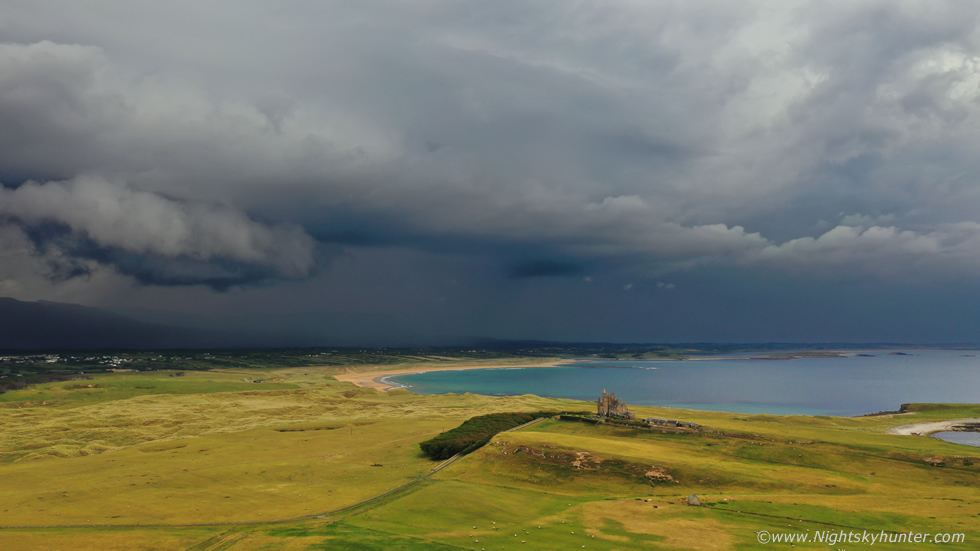 |
Panning the drone to the right, that's the majestic Classiebawn Castle, behind it pink in-cloud lightning bolts whipped and flashed, some where unseen deep inside the precip and yet others sparked high up within the updraught tower, I could tell this by the variation in acoustics. I could feel a few spots of precip on my face so I brought the drone in and hand caught it and packed it away.
 |
Like a scene over the prairies of the USA, storm morphing from inflow to outflow yet still exhibiting traits from each. The scud lowerings were rising upward as warm inflow was being ingested into the base of the updraught, then over time the rain cooled air from the core behind began to under cut forcing the cloud tags forward and upward as outflow mode took over. You can still glimpse the bright white anvil edge in the gap above, I was really loving the dynamic range of this 5D Mark IV. I glanced behind me, Colleen was shooting video and time lapse with her mobile phone mounted on a gorilla type tripod, to my left was John shooting wide angle stills, all three of us were buzzing and in the zone, excited chat filled the air. In the distance Paul was on the top of the road shooting the left side of the storm and unseen around the corner was Nigel, unknown to me at the time he had his Mavic 2 Pro in the air and had taken an outstanding aerial panorama of the storm.
 |
Shelf cloud, also known as an Arcus Cloud, now filling the 10mm frame of the 600D. To my right the storm was still flashing with lightning and the thunder was getting louder as the danger area crept closer, however I was more than happy to stand in this field up close and personal with the storm. The sight of us all out with the cameras looking at the sky drew much attention, many people asked us what we were doing and we explained about the storm and time lapse photography and they were all fascinated, our presence and the attention we were paying towards the storm seemed to generate much curiosity.
 |
I ended up getting two very nice wide angle time lapse scenes from both cameras of this entire storm approaching, from the anvil stage upon arrival to the frame filing shelf here.
 |
I grabbed both cameras and ran up the hill to see Paul, as always he was on to a cool scene. This is the N side of the storm which had new cell formation and it looked mean with a solid conglomeration of cloud accompanied by new rumbles of thunder. I began shooting a time lapse with the 5D sitting on a stone wall and used the 600D for stills. The horizon is level here however the road and field sloped steeply upward on the left. We observed cloud along the leading edge rotate. An elderly couple arrived with their cameras and began shooting the storm too, once they heard me say the lightning would be closer soon and that we would be in the danger zone they quickly retreated. Kenneth from Donegal Weather Channel and Noel Keating pulled up for a chat, they were chasing too, the last time we meet was during the last big storm day, it seems we always meet our fellow chaser companions on the west coast under the updraughts of storms.
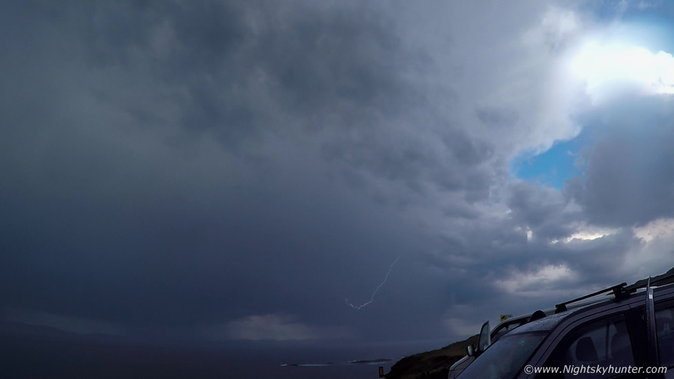 |
The storm hit, the rain turned torrential and we ran to the cars and vans and took shelter, we were treated to a very prolonged lightning show. We relocated along the coast and parked facing out west across the ocean. Counting Noel and Kenneth that made seven chase vehicles on location. We watched lightning for well over an hour, perhaps as much as an hour and a half, I saw more lightning this day than the last two years combined. My attempts at capturing it were half hearted, I'm not as much into day time lightning as I prefer storm structure and dramatic clouds, I had already bagged my trophy shots of the day and had accumulated several significant time lapses as well so I was more than happy. I just set the Go Pro on the van bonnet and enjoyed the scene visually while chatting with the guys. I did capture this in-cloud bolt on the Go Pro footage.
 |
After what felt like two hours of thunder the precip core began to pass out to sea and I could glimpse the back end of the storm with a clearance behind, I took this one leaning out the van window, note how solid the anvil was with mammatus forming.
 |
This strange cloud formation appeared at the flank of the storm, it didn't appear to be rotating and wasn't attached to the base however it definitely had a tubular vortex appearance. It was interesting enough to get an image, just scud, or was it the detached roped out remains of a high based funnel cloud which went unseen when the precip core was over us?
 |
As the storm moved out to sea a new cell formed at the rear towards Donegal, it looked very impressive and organized with updraught and flanking towers and anvil sporting mammatus, the precip core was sheared for miles across the ocean to the W (L). I set up both DSLRs and shot my final time lapse of the day. The storms died out an hour before sunset then we said our final farewells to the clouds and each other and called it a day, we had a long drive back, however the drive is always an easy one when you have a successful day and once again Mullaghmore treated us to a fine show. On the way home Nigel and I chatted over the radio, I got so engrossed I hadn't realized that I had been following Nigel home and I was going in the wrong direction. I had to get my bearings then double back on myself and take a 20 mile detour across country to get back in the area I wanted. As I ascended the hills above Co. Fermanagh I saw a stunning sunset skyscape in the wing mirror. Two back lit charcoal black towers dominated the W skyline, the sun visible as a red disk was visible below the most robust tower casting the precip core in deep red hues, it was the perfect end to a perfect day. When I got back home in Cookstown it was 23.30 BST, I had been chasing for 13.5 hours, it took me to 02.00 in the morning to download all my images from three DSLRs and drone and transfer them to an external hard drive, then I re-charged the batteries on all devices and studied the forecast in preparation of another days storm chasing the following day.
Mullaghmore storm chase vlog and time lapse from June 14th, it took me three days and nights to render the time lapse sequences and edit this video. I had taken more than 12,000 still images using 18MP and 30.4MP DSLRs, mobile phone footage and Go Pro footage so it took a long time to sort through the files to get this presentation ready, I really hope you enjoy it.
Time lapse sequences without any vlog for those interested in this aspect of storm photography. I was shooting with 1 second intervals between images with both cameras and rendered at 24 frames/second at 1080p HD, in the above clip I sped up the main sequences by a factor of 1.5x times. This day was a great adventure and the best storm chase I have had in years, I was surround by great skies and great friends, new memories have been made and if the Summer of 2020 went stormless after this I wouldn't mind as this day provided me with the perfect storm fix. As luck would have it Monday June 15th looked to be another big day with high CAPE values and good shear so I got some sleep in preparation for my second day on the road which will feature in the next report, thanks very much for reading.
Martin McKenna